
ERA 04
Steppe and Bronze Age Europe
5,000 - 1,100 years ago
From
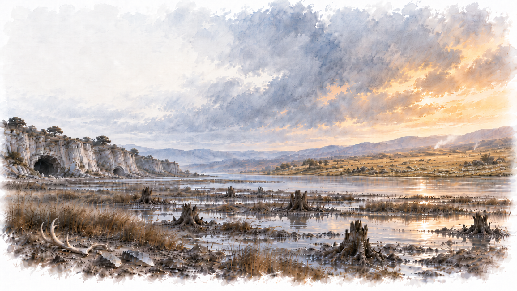
This era covers the return of the first people to Britain as the ice retreated, the loss of Doggerland, and the rise of farming that would carry new ancestral lines across a transforming Europe and, at last, over the water into Britain itself.
In This Era

09
Britain’s Earliest People
Caves, Cousins and Colonisation
As the ice retreated, Britain remained joined to continental Europe by dry land, allowing people to move back into a country from which humans had been absent for many thousands of years. None of these earliest people can yet be placed on the particular ancestral paths traced back from Ursula, Xenia, Oisin or Wodan, although some would prove to belong to neighbouring branches of the same wider genetic families. What follows is therefore the story of the country itself: repeatedly occupied and recolonised by different peoples, and of the landscape into which those later family lines would eventually arrive.
The earliest genomes recovered from Britain reveal just how varied those arrivals were. Rather than a single population spreading steadily across the country, at least two genetically distinct groups reached Britain within little more than a thousand years of one another.
The first is represented by a woman who lived at Gough’s Cave in Somerset around 15,000 years ago. Her ancestry belonged to the older population associated with Magdalenian Europe, closely related to people living in Belgium and Spain at around the same time. Her people hunted animals including red deer, wild cattle and horse. The cave preserves a darker part of their world as well. Human bones were cut, broken and deliberately modified, and some skulls were shaped into cups, evidence interpreted as part of complex mortuary practices that included cannibalism.
Little more than a thousand years later, a very different population had reached Britain. At Kendrick’s Cave on Great Orme in North Wales, a man who lived around 13,500 years ago carried ancestry related to the Villabruna population then spreading through western Europe. His people’s diet, rich in marine and freshwater foods, and his burial at a site associated with a decorated horse jaw and pierced tooth ornaments rather than butchered animal remains, point to a genuinely different way of life from the one practised at Gough’s Cave.
For Ursula, the Kendrick’s Cave man carries an additional significance. His mitochondrial DNA belonged to U5a2, a sibling branch of the U5a1 lineage traced back from Ursula. A close maternal cousin within her wider genetic family had therefore already reached the far northwestern edge of Europe by the closing stages of the Ice Age.
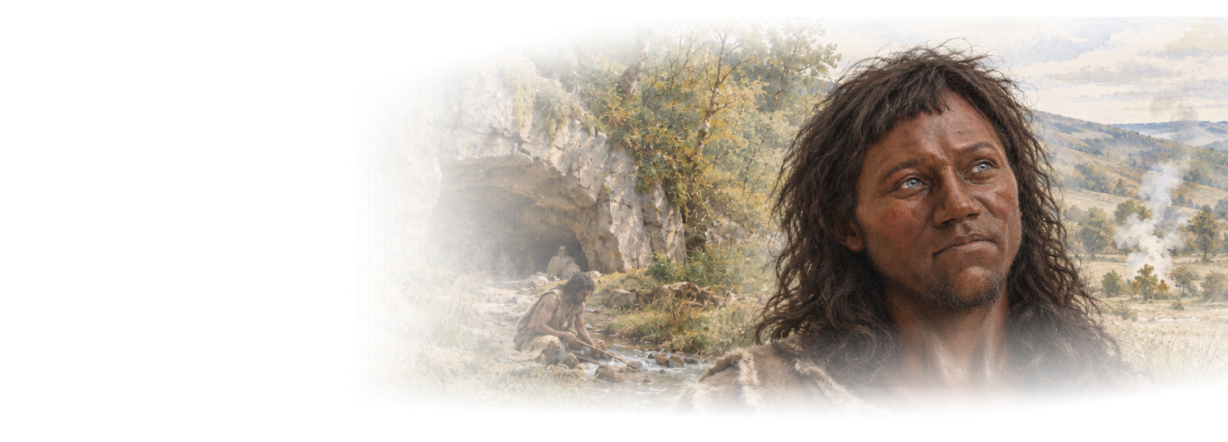
By the beginning of the Mesolithic, evidence of human presence reaches much farther north. At Heaning Wood Bone Cave in Cumbria, a young female was buried between 9,290 and 8,925 cal BCE. Nicknamed Ossick Lass, she is the earliest known human burial from northern Britain. Her body appears to have been deliberately placed in the cave, accompanied by tiny pierced periwinkle shells, probably once arranged or worn as beads.
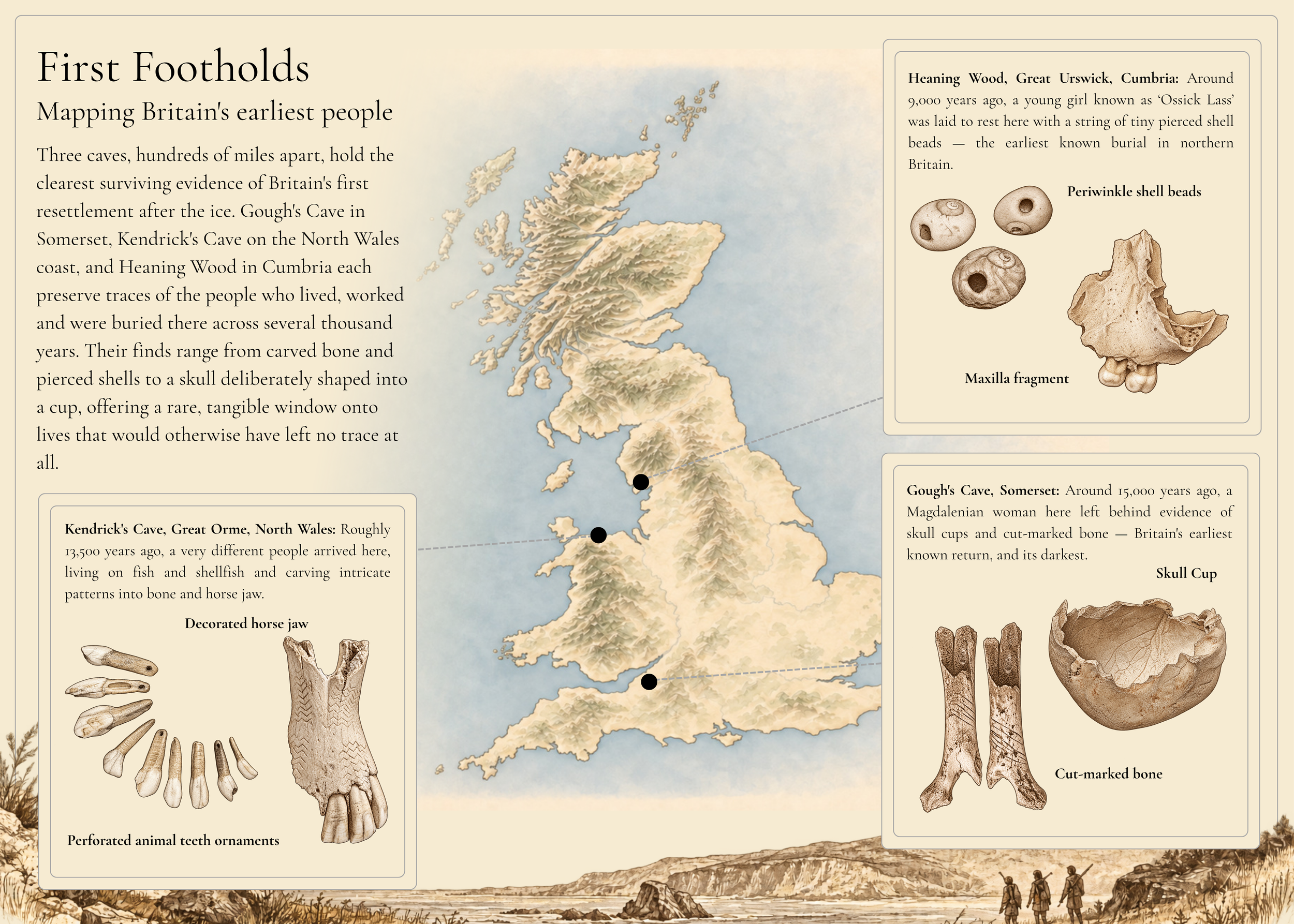
Site map of Britain's earliest arrivals. The locations of Gough's Cave (Somerset) (Bello et al. 2011; Bello et al. 2017) and Kendrick's Cave (Great Orme, North Wales) (Płonka & Kowalski 2017) and Heaning Wood Bone Cave (Cumbria) (Warburton et al. 2026), the three sites that preserve the clearest surviving evidence of the people who first reached Britain after the ice retreated, alongside a selection of the objects recovered from each.
Several centuries later, Gough’s Cave enters the picture again. Thousands of years after the Magdalenian woman had lived there, people from a different Mesolithic population were returning to the same limestone gorge. Among them was the man now known as Cheddar Man, buried between 8,607 and 7,982 cal BCE.
His Britain was greener than the one known to the first people at Gough’s Cave. The open landscapes of the Late Glacial had given way increasingly to woodland, rivers and wetlands, and Mesolithic communities lived by hunting, fishing and gathering wild foods. Gough’s Cave itself preserves evidence of people returning to the area at widely separated periods rather than one continuous settlement.
Cheddar Man stood around 166 cm tall, a little above the broader average for Mesolithic men in western Europe. Even so, study of his skeleton placed him towards the smaller end of the range for men living at around the same time.
He also brings two of the wider family stories together in a single individual. His Y chromosome belonged to I-M423/I2a, within the same broad paternal family as Wodan, while his mitochondrial DNA belonged to U5b1, a major sibling branch of Ursula’s U5a maternal family. Neither is the particular branch traced back from Ursula or Wodan, but both are collateral branches of those wider genetic families. Oisin’s and Xenia’s descendants had yet to leave any trace here; their stories were still unfolding elsewhere.
The prominence of caves in this early British evidence is partly a consequence of what survives. It does not mean that these communities spent their lives deep underground. Much human activity took place around cave entrances and across the surrounding landscape, while caves could also serve other purposes, including burial and the treatment of the dead. Their protected conditions preserved bone, antler and other fragile remains that have vanished from many open-air sites. Britain’s earliest inhabitants lived across a much wider landscape than the caves alone suggest; caves are simply among the places where some of their most intimate traces survived.
Britain was not returned to by one people, but rediscovered again and again, by those arriving on foot across land joined to the rest of the continent, ground that was already, slowly, disappearing beneath the sea.
10
Beneath the North Sea
Rising Seas and Isolation
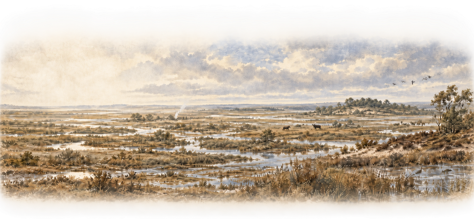
By the end of the Ice Age, Britain was still physically joined to continental Europe. Beneath what is now the southern North Sea stretched Doggerland, a broad low-lying country of rivers, wetlands, lakes and coastlines connecting the two. It was not merely a route into Britain, but an inhabited landscape in its own right.
That habitation has left a real, if scattered, physical record. Since the mid-twentieth century, fishing trawlers and Dutch coastal dredging have recovered thousands of bone, antler and flint tools from the seabed and beaches, along with dozens of human remains, preserved by the oxygen-poor conditions of the submerged sediment. Among them are several mandibles, robust and large-toothed by modern standards, one of them hauled up by a fishing boat and later confirmed through radiocarbon dating to belong to the Mesolithic period. Isotope analysis of around thirty such finds shows that Doggerland's inhabitants relied overwhelmingly on freshwater food sources rather than the sea, a picture at odds with the common assumption that a people whose remains now wash up on beaches must once have lived by the coast. Alongside tools of animal bone and antler recovered from the same waters, at least two barbed hunting points were found to have been made not from animal bone but from the bones of the dead themselves, a discovery that points to a similarly complex and deliberate treatment of human remains as that already seen at Gough's Cave, arising independently in a very different landscape.
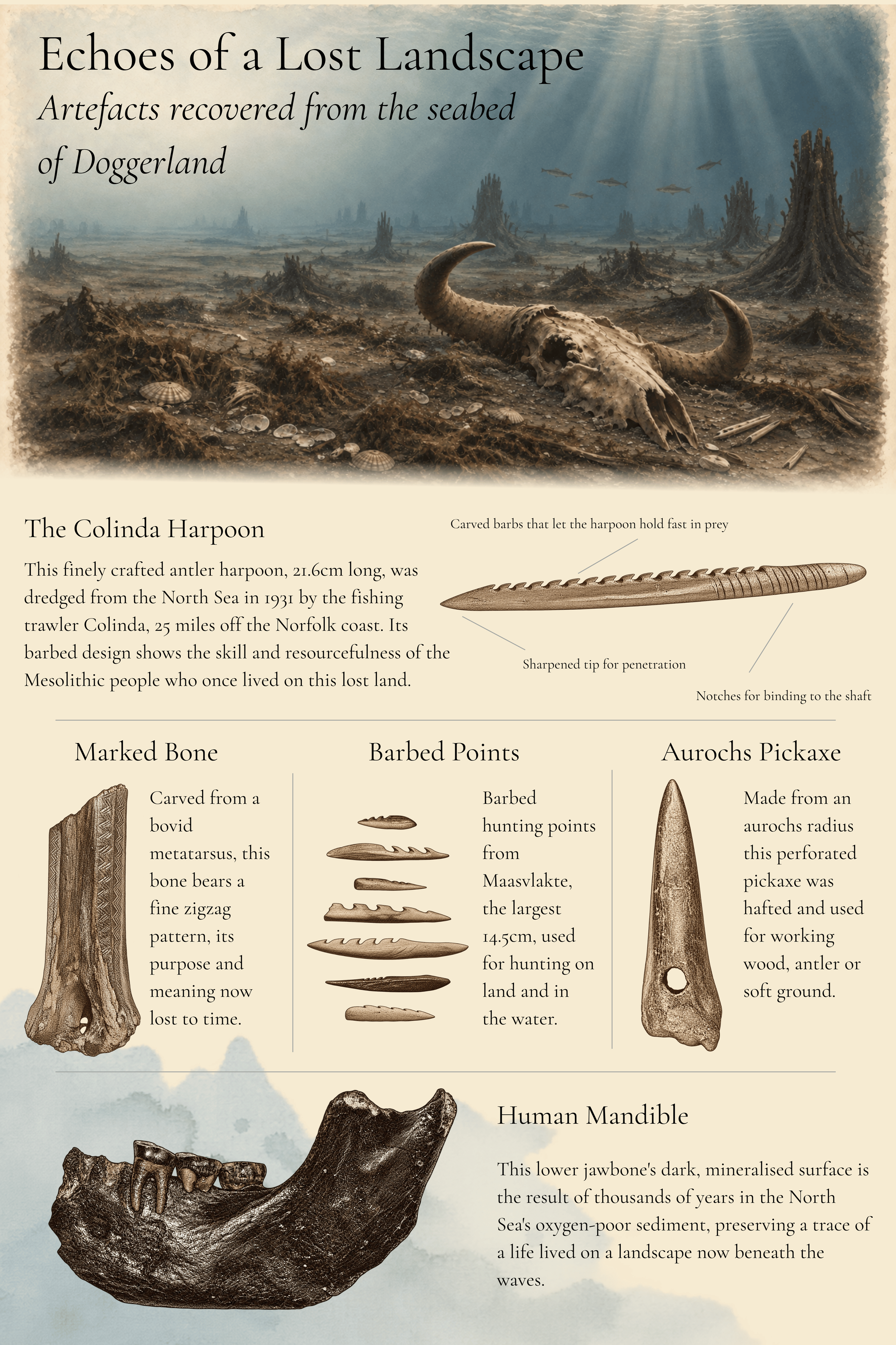
Selected artefacts recovered from the submerged landscape of Doggerland. Items recovered by fishing trawlers and coastal dredging from the southern North Sea over the past century. The human mandible was recovered along with dozens of similar finds analysed for diet and dating (Storm et al. 2014; van der Plicht et al. 2016; Altena et al. 2022). Barbed hunting points of bone and antler, some made from human bone rather than animal remains, are among the most common artefact types recovered from the area (Dekker et al. 2021).
For thousands of years this connection survived, but the sea was steadily dismantling it. As the remaining ice sheets melted, sea levels rose and the lowest ground disappeared. The process took millennia rather than centuries and did not proceed at a smooth, predictable pace. At times the rise accelerated, then slowed again, repeatedly redrawing river mouths and coastlines and turning familiar ground first into marsh, then tidal water and finally open sea. Sea level in the region rose in two distinct pulses rather than smoothly: one peaking around 10,300 years ago and a second around 8,300 years ago, each driven by meltwater surging from the melting ice sheets of North America and Antarctica, at rates comparable to the fastest sea-level rise now projected for the next century. For the people living there, these were not simply changes on a map. Coastlines, estuaries and hunting grounds familiar to one generation could look very different to the next, and there is some evidence that diet itself shifted accordingly, growing steadily more dependent on aquatic food over time as the landscape grew wetter.
By around 9,000 years ago, much of the former plain had already been lost and Doggerland was becoming increasingly fragmented, although higher ground around what is now Dogger Bank survived for longer. Recent modelling suggests the losses came earlier and more sharply than once thought, with a marked phase of land loss around 10,500 to 10,000 years ago, a period that also shows a measurable rise in the intensity of human activity recorded at nearby sites in the Netherlands and northwest Germany, as though communities were concentrating onto the ground that remained. It was a landscape already undergoing profound change before its most dramatic shock arrived.
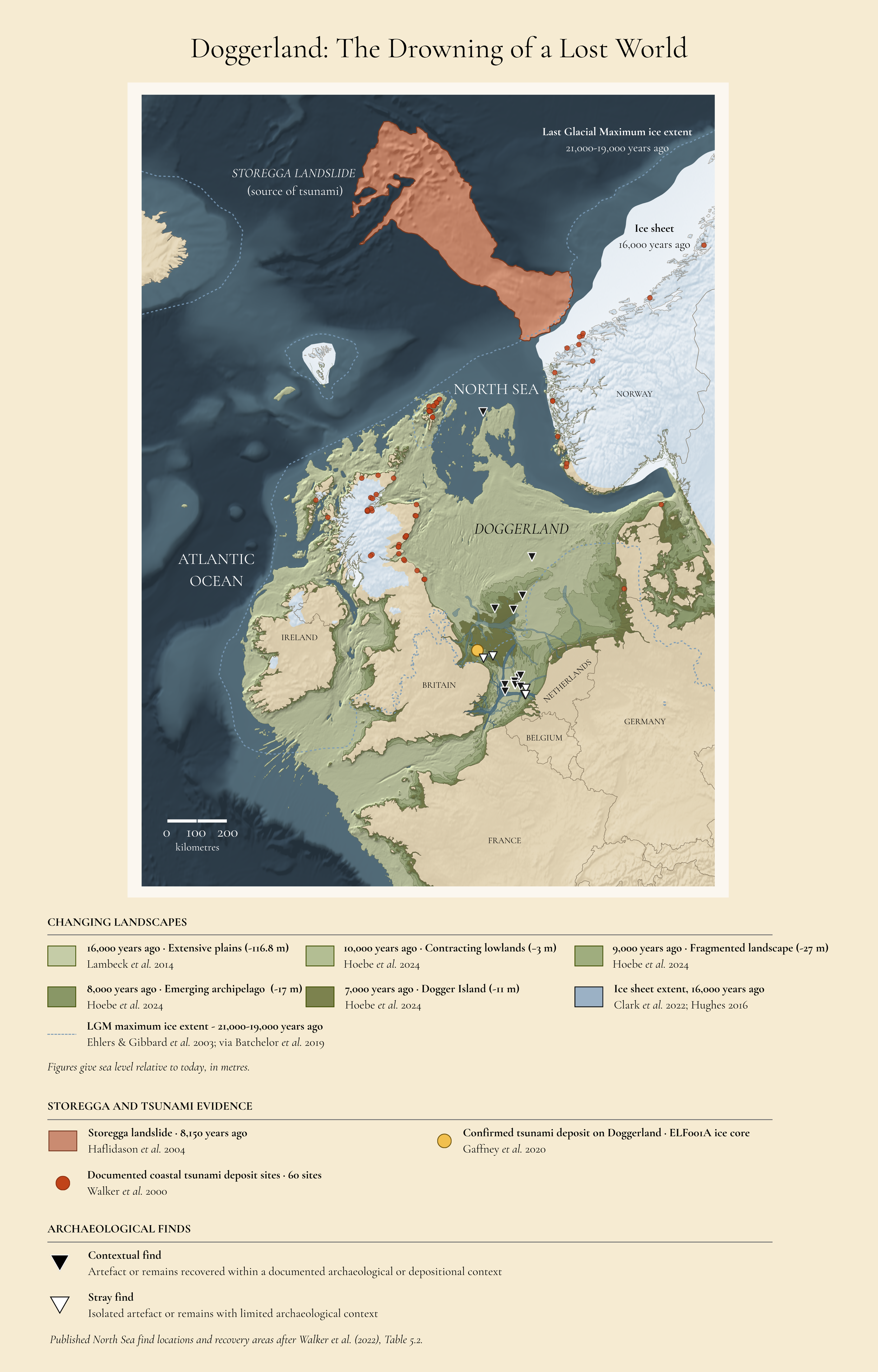
Evidence from the Seabed: Reconstructing Doggerland's Final Centuries. This reconstruction traces the North Sea basin through five real coastline stages, from the open plains of 16,000 years ago to the last fragments of Dogger Island around 7,000 years ago, built from EMODnet bathymetry and the sea-level modelling of Lambeck et al. (2014) and Hoebe et al. (2024). The retreating Last Glacial Maximum ice sheet (Clark et al. 2022; Hughes 2016) is shown at 16,000 years ago, with the ice front of 21,000 to 19,000 years ago marked for comparison. Around 8,150 years ago, in the span between the 9,000 and 8,000-year stages shown here, the Storegga Slide, one of the largest submarine landslides known, triggered a tsunami whose deposits are recorded at 60 sites around the North Sea coast (Walker et al. 2020) and, remarkably, within a buried river channel on Doggerland itself (Gaffney et al. 2020). The triangles mark real archaeological finds from this drowned North Sea landscape, from a Mesolithic barbed antler point trawled up in 1931 to flint scatters recovered from Brown Bank and the Eurogeul, distinguishing finds recovered in a documented context from stray, isolated discoveries (after Walker et al. 2022, Table 5.2).
Then, around 6,150 BCE, one of the largest submarine landslides of the Holocene occurred off western Norway. Roughly 3,200 cubic kilometres of sediment collapsed beneath the sea, generating the Storegga tsunami. The resulting waves reached as high as 20 metres around the Shetland Isles and were still several metres high when they struck parts of the northern English coast.
For many years Storegga was portrayed as the catastrophe that finally drowned Doggerland. The newer evidence is more complicated. Much of the landscape had already disappeared before the tsunami struck, and its effects varied sharply according to local topography. Some surviving areas appear to have endured the wave and remained above water afterwards. Doggerland was therefore not erased in a single terrible day; Storegga was a violent interruption within a much longer history of rising seas and shrinking land.
For people directly in its path, however, the consequences could still have been severe. At Howick on the Northumberland coast, Mesolithic people lived beside a resource-rich coastal landscape, drawing food from the coast, woodland and surrounding waters. The tsunami coincided with a real and significant decline in the region’s Mesolithic population. Modelling also suggests that the state of the tide may have been critical: if Storegga arrived near high tide, inundation could have reached the settlement itself, threatening both the people living there and the coastal resources on which they depended. Whether Howick itself suffered such a direct hit remains uncertain.
Even Storegga was not quite the end. Fragments of the old landscape survived afterwards before continued sea-level rise finally removed the remaining connection. Britain had become an island, but it had not become isolated.
When the next great population movement reached Britain, it would come by boat.
11
The Age of Farming
Cultivation and Conflict
Around 10,000 years ago, in the hills, plains and river valleys of Southwest Asia, people began reorganising one of the most fundamental parts of human life: how they fed their communities. Rather than relying entirely on wild plants and animals, communities increasingly cultivated crops, managed herds and invested labour in particular pieces of land. This was not a single invention made by one population. Ancient DNA shows that the early farming communities of the Levant, Anatolia and the Zagros emerged from genetically differentiated populations that had developed in different parts of Southwest Asia before later mixing with one another.
Along the Iron Gates of the Danube, where the river cuts between the Carpathians and the Balkans, communities had already been living beside the water for thousands of years. More than thirty archaeological sites are known from the Danube Gorges, preserving over four millennia of occupation. These were comparatively settled hunter-gatherer communities whose lives revolved around the river and the surrounding landscape. Their dead were buried in several different ways, most commonly laid out on their backs, but sometimes seated in striking flexed positions; secondary burial and cremation were also practised.
Their surviving tools make that world unusually tangible. Microscopic wear and residues on stone artefacts from Padina and Lepenski Vir show people butchering animals, preparing hides, working bone and antler, processing plants and working soft stone. Some activities were concentrated in particular areas of the settlements, suggesting organised working spaces rather than a succession of temporary camps.
It is here, long before farming reached the gorge, that Ursula's maternal story reappears.
At Padina, in present-day Serbia, one individual buried between 9,140 and 8,570 cal BCE carried mitochondrial haplogroup U5a1c, a collateral branch within Ursula's wider U5a1 family. A little later, between 8,805 and 8,355 cal BCE, another person was buried at Padina. We might call her Uska. Her mitochondrial DNA belonged to U5a1, placing her directly on the maternal branch that would later lead towards Ursula’s U5a1a1 lineage.
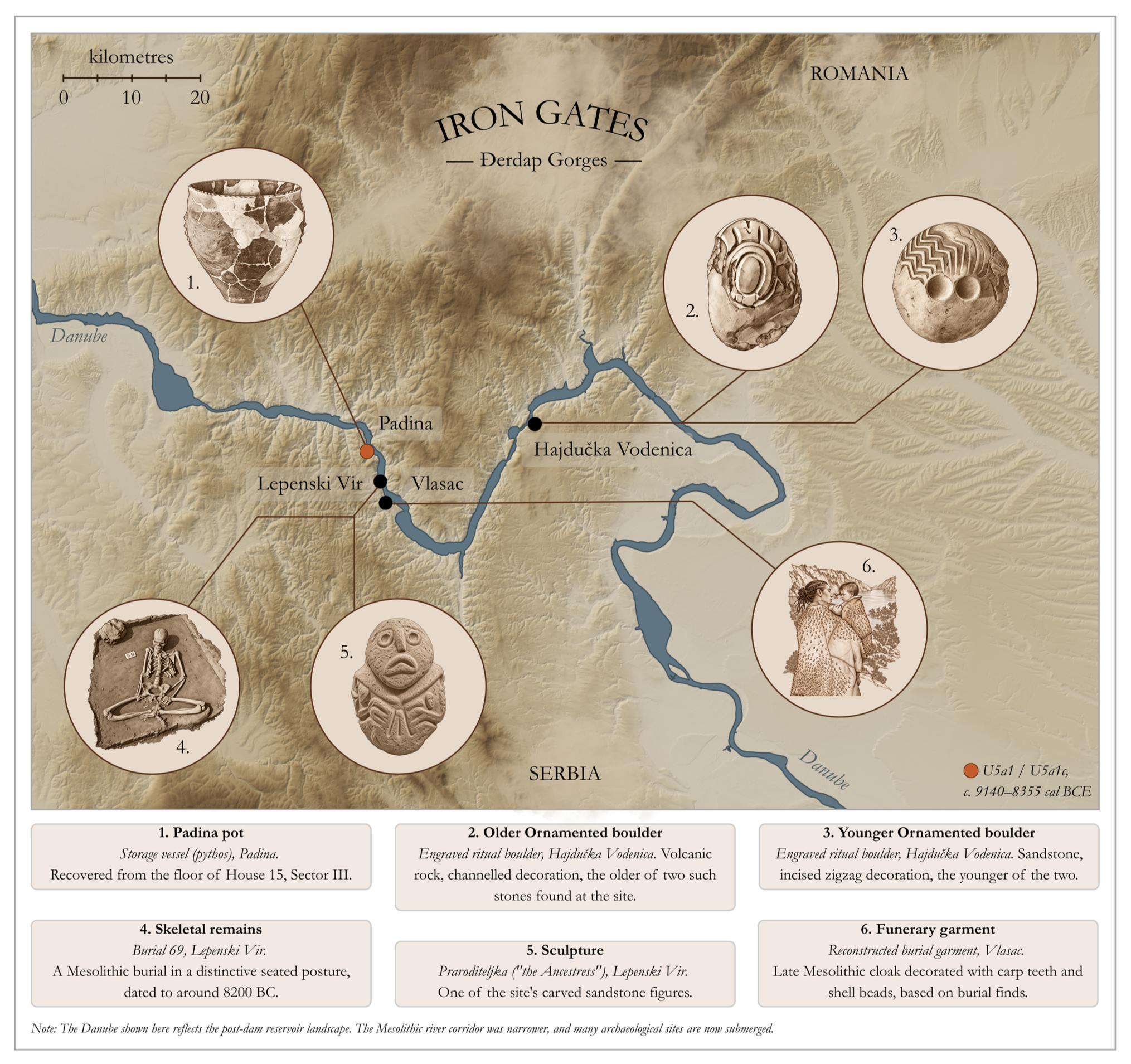
Mesolithic sites of the Danube Gorges. The Danube gorges between Golubac and Hajdučka Vodenica, home to the Mesolithic communities of Padina, Lepenski Vir, Vlasac and Hajdučka Vodenica. Images from Jovanović 2008 (Documenta Praehistorica 35); Cristiani & Borić 2012; National Museum of Belgrade. Terrain and river data from the Copernicus Digital Elevation Model and the EU-Hydro River Network Database.
Uska therefore belongs firmly to the older Mesolithic world, when communities still lived by fishing, hunting and gathering wild foods, long before cultivated fields and managed herds reshaped the landscape. In the Danube Gorges, the main Mesolithic occupation falls broadly between about 9500 and 7500 cal BCE, while the transition towards the Neolithic, the new world of farming and settled agricultural communities, begins only around 6200 BCE and is established by about 6000 BCE. Uska had lived more than two thousand years before that transformation. Ursula's line was therefore already embedded in southeastern Europe's hunter-gatherer population long before farming reached this stretch of the Danube.
The genetics also show why these ancient branches should not be imagined as a succession in which one simply replaces another. The U5a1c individual at Padina belonged to one offshoot of U5a1, while Uska belonged to the ancestral U5a1 branch itself. Both could exist at the same time, just as older branches can continue for thousands of years after younger ones have emerged from them.
When farmers eventually did reach the Iron Gates, the old population did not simply disappear. The region became one of the places where hunter-gatherers and farmers interacted and mixed. Nor does the skeletal evidence suggest that their encounter inevitably produced warfare. A study of more than 400 individuals from Lepenski Vir, Vlasac, Padina and Hajdučka Vodenica found interpersonal violence to have been relatively uncommon and sporadic, with no clear increase accompanying the arrival of farming. The transition could be profound without necessarily being catastrophic.
Farther south, however, farming had already produced a kind of human community unlike anything the earlier hunter-gatherer world had known.
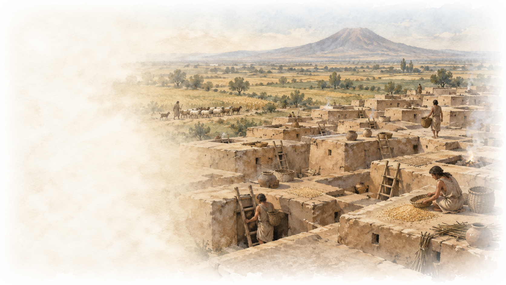
At Çatalhöyük, on the Konya Plain of central Anatolia, a settlement founded around 7100 BCE grew across approximately 13 hectares. Mud-brick houses stood packed closely together, often with little open space between them. People appear to have moved across the rooftops and entered houses through openings above. Buildings were occupied for decades, then dismantled and rebuilt on roughly the same footprint, generation after generation, until the mound accumulated almost 21 metres of archaeological deposits. Occupation continued for around 1,150 years, and at its Middle Period peak perhaps 3,500 to 8,000 people were living there at the same time. No palace or monumental public building dominated the settlement; the house remained the basic unit of everyday life.
The difference from the world Uska had known at Padina was immense. Thousands of people were now living together, generation after generation, in one densely occupied place. Çatalhöyük has therefore been described as having the characteristics of a proto-urban settlement, although it lacked many of the institutions that would define later cities.
And each house contained far more than the activities of the living. People prepared food, worked, stored possessions and carried out ritual practices there, while their dead were buried beneath floors and raised platforms. Some buildings accumulated unusually large numbers of burials over generations. A household could therefore contain both the living family and the physical presence of people who had died decades earlier106.
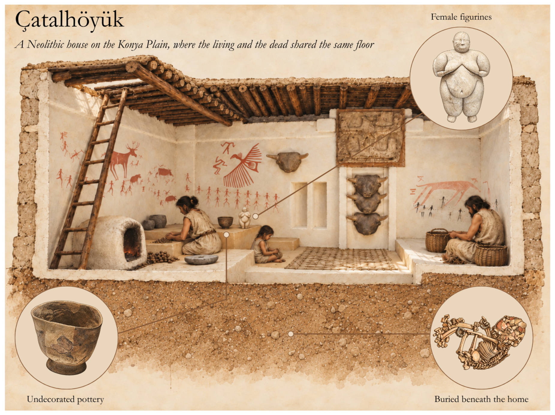
Reconstruction of a Çatalhöyük house. Room reconstruction based on the Çatalhöyük Experimental House. Marble figurine: a mature standing female figure, excavated in Building 150, 2016 season, dated to c. 6300-6000 BC (Çatalhöyük Research Project). Burial: an infant aged 6-12 months, buried beneath the floor with bone-bead bracelets and anklets and traces of red ochre; excavation diary, Cambridge University Çatalhöyük archive (1999), via the Roy Rosenzweig Center for History and New Media. Pottery: a plain, dark-burnished bowl typical of Çatalhöyük's undecorated Neolithic ware, East Mound.
It is inside this remarkable community that Xenia's wider maternal family becomes visible.
One Early Neolithic individual, cch230, carried mitochondrial haplogroup X2b45. X2b is not the X2c branch later represented by Xanthe, but a sibling branch descended from their shared X2 ancestry. cch230 therefore cannot date the origin of X2c itself. What this individual does show is that Xenia's wider X2 family had already diversified within the early farming world of Anatolia, even though the point at which X2c itself emerged remains unknown.
Çatalhöyük makes that maternal connection particularly intriguing. Ancient DNA from 131 individuals buried within 35 buildings has shown that, particularly in the earlier settlement, people buried within the same houses were often biologically related and that those connections were disproportionately maintained through female lines. The social organisation changed through time, but maternal relationships remained unusually prominent. Xenia's close maternal cousin therefore appears in a community in which maternal kinship itself seems to have played an important role in structuring households and burial.
The advantages of living in such numbers came with new costs.
Çatalhöyük's inhabitants relied increasingly on domesticated plants and animals, particularly cereal crops and sheep and goats. Higher fertility helped the settlement grow, but greater population density increased labour demands, placed pressure on nearby resources and brought large numbers of people, animals and waste into close proximity. Bioarchaeological evidence records dental disease associated with carbohydrate-rich food, greater exposure to infection, increasing workload and the need to travel farther for herding and other resources as the settlement expanded.
Violence is also visible. Cranial injuries became more frequent during the periods of greatest population density, although that association does not prove that crowding itself caused them. Çatalhöyük instead provides something rarer: a record of almost twelve centuries in which the biological consequences of living in a very large, increasingly crowded permanent community can actually be followed through human skeletons.
Yet this was not a miniature version of the hierarchical cities that would emerge thousands of years later. Recent analysis finds no evidence for durable, institutionalised inequality at Çatalhöyük. Access to staple foods was broadly similar, although differences existed between households in some goods and activities and inequality appears to have increased temporarily during part of the settlement's history.
From Anatolia and southeastern Europe, farming spread westwards across the continent along two broad fronts. One travelled through the Aegean, Balkans and Danube corridor into central Europe; the other followed the Mediterranean coastline towards Italy, southern France and Iberia. Ancient DNA shows that these movements involved substantial migration by populations related to Anatolian farmers rather than simply the spread of agricultural knowledge, followed by varying degrees of admixture with indigenous hunter-gatherers in different parts of Europe.
The genetic impact was dramatic, but it was not the same everywhere. Across much of western and central Europe, incoming farming populations rapidly came to dominate the genetic record, producing near-total replacement of hunter-gatherer ancestry in some regions. Farther east, a very different pattern persisted. Ancient DNA reveals a broad genomic divide running roughly from the Black Sea to the Baltic: west of it, the spread of farming brought major population change, while east of it hunter-gatherer populations remained genetically dominant for thousands of years longer. Farming was transforming Europe on both sides of this boundary, but it was not always being carried by the same kind of population movement.
The two routes also developed recognisably different archaeological traditions. Along the Mediterranean, Cardial pottery was characteristically decorated by pressing the serrated edge of cockle shells into wet clay. Farther north, the Linearbandkeramik, or LBK, took its name from the linear or banded decoration on its vessels. These were not merely decorative fashions. Alongside crops, domestic animals, tools and houses, they provide a visible archaeological fingerprint of the different communities through which farming spread.
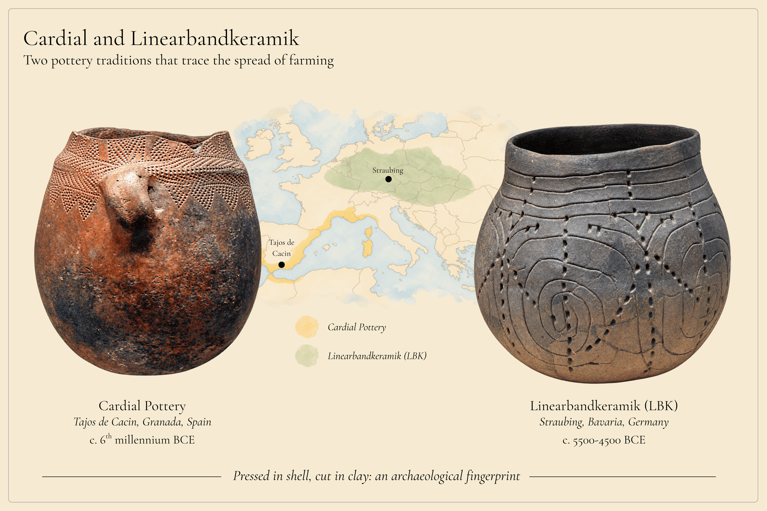
Cardial and Linearbandkeramik pottery traditions. Distribution zones for Cardial and Linearbandkeramik (LBK) pottery, the two archaeological traditions that mark farming's two main routes into Neolithic Europe, after Olalde et al. 2015. Cardial ware takes its name from its characteristic decoration, impressed with the serrated edge of cockle shells pressed into wet clay before firing. LBK ware is named for its incised linear and banded ornament, typically spirals and parallel bands scored into the surface with a pointed tool. Cardial pot: Tajos de Cacín, Granada, Spain; photo by José-Manuel Benito Álvarez. LBK pot: Straubing, Lower Bavaria, Germany; Gäubodenmuseum.
Pottery itself was not invented by farmers, but it became increasingly useful within settled agricultural life. Harvested crops could be stored for later use rather than consumed immediately, making storage an important part of the new farming economy. Ceramic vessels provided durable containers for that purpose, while archaeological examples also show vessels being used for cooking as well as storage.
As farming spread, the transformation was demographic as well as technological. Cultivation and livestock husbandry could sustain larger populations, while the ability to produce and store food changed the way communities planned for the future. Settlements became more permanent, fields demanded repeated investment and livestock became resources that could be managed across generations. Diets changed too, while denser populations and sustained proximity to domestic animals and waste increased exposure to infection. Farming brought enormous advantages, but also new vulnerabilities to crop failure, disease and pressure on local resources.
Permanent settlement also created new possibilities for organising land, livestock, labour and inheritance, although Çatalhöyük itself shows that agriculture did not automatically produce durable hierarchy or a single pattern of family organisation.
By the sixth millennium BCE, the farming world had travelled astonishingly far from its Southwest Asian beginnings. Crops and livestock had crossed the Mediterranean, entered Iberia and penetrated landscapes that at first glance hardly seem suited to the lives of early farmers.
High in the central Pyrenees, more than 1,500 metres above sea level, lay the cave of Els Trocs. Around 5,300 BCE, an adult man carrying I-L161.1, whom we might call Waska, belonged to the Early Neolithic population using this mountain landscape. I-L161.1 lies directly on Wodan's paternal lineage, making Waska one of the earliest ancient individuals used here to carry a marker on the line leading towards the branch preserved in the family today.
Els Trocs was not merely an isolated shelter occasionally visited by wandering farmers. More than 4,000 sheep and goat remains have been recovered from the cave, and isotopic evidence from sheep teeth demonstrates regular movement between different altitudes. The cave was seasonally occupied throughout the Neolithic, and livestock were being brought into the Pyrenean highlands from the Early Neolithic. Mobile herding was already an integral part of the farming economy.
Waska's community was therefore living very differently from the people represented by Uska at Padina. Their livelihood depended not simply on exploiting wild animals but on managing domestic flocks, planning seasonal movement through a mountain landscape and returning to high pastures as part of an organised pastoral economy.
For Waska and the other earliest inhabitants of Els Trocs, however, that story ended violently.
Waska was an adult man from the cave's earliest occupation, with remains dating to around 5,308–5,080 cal BCE. He was one of nine people from this earliest occupation, five adults and four children, whose deaths appear to belong to a single episode of extreme violence.
Several of the adults had been struck in the head by arrows, while both adults and children suffered severe blunt-force injuries. Most of the bodies were later found disarticulated and scattered through the cave, many of the bones deliberately broken. The evidence suggests that the attack took place outside and that the victims were carried into the cave soon afterwards. Bows would have been difficult to use effectively in its confined, poorly lit interior, while the bones show little sign that the bodies had been left exposed before they were moved.
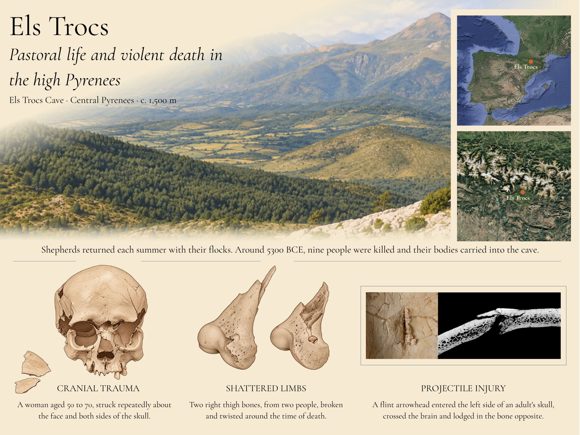
The massacre at Els Trocs, c. 5300 BCE. Els Trocs is a cave at 1,564 m on the southern slopes of the central Pyrenees, in Huesca. From around 5300 BCE it was occupied for a few weeks each summer by shepherds who climbed from the valleys below with their flocks, and who floored it wall to wall with more than seventeen thousand potsherds. In one of those early summers nine people, five adults and four children, were killed in a single episode and their bodies carried inside. Waska was one of them. His remains show blunt force injuries to skull and limbs, but he is not among the individuals shown here: the cranium is that of a woman aged 50 to 70, the thigh bones belong to two unidentified individuals, and the arrow wound is that of an adult whose sex could not be determined.
Landscape: artist's impression of the Selvaplana plateau from the pass of the Puerto de las Aras, after a photograph by H. Arcusa Magallón. Maps: imagery © Google. Cranium and thigh bones: illustrations after photographs by T. Schuerch. Projectile injury: photograph by T. Schuerch, micro-CT by G. Schulz, panel labels removed. All specimen images from Alt, K.W., et al. (2020), reproduced and adapted under CC BY 4.0. Site chronology and seasonal occupation after Tejedor-Rodríguez, C., et al. (2021).
We cannot say exactly how Waska himself died. The clearest individually identified arrow wounds belong to other members of the group, so assigning one of those injuries specifically to him goes beyond the evidence.
Nor can archaeology identify the killers. Conflict between incoming farmers and indigenous hunter-gatherers has been proposed, as has violence between rival farming communities competing over territory, animals or resources. The evidence cannot presently distinguish between them, so Els Trocs cannot be explained simply as a clash between incoming farmers and local hunter-gatherers.
Uska's Iron Gates world shows how different that encounter could be elsewhere. There, hunter-gatherers and farmers eventually came into prolonged contact without any comparable archaeological evidence for an epidemic of violence. Farming did not make violence inevitable. What it did was alter the human landscape in which disputes could occur: more people, cultivated ground, stored resources, livestock and increasingly persistent claims to particular places.
Waska's genetics add another layer. His Y chromosome carried I-L161.1, directly on Wodan's paternal line, while his mitochondrial DNA, inherited independently from his mother, was N1a1a1, a maternal lineage well represented among Early Neolithic populations of central Europe. The Els Trocs researchers noted that this maternal lineage was unusual in Early Neolithic Iberia and discussed possible northern connections through France.
By Waska's lifetime, the paternal line descending from Wodan was being carried within a community fully engaged in farming, livestock management and seasonal movement through the Pyrenean landscape. It had not been swept aside by agriculture; it had survived into the farming world.
And Waska was not its final appearance.
Several centuries later, around 4,766–4,601 BCE, another man, SX33, was buried at Lingolsheim in Alsace, close to the Rhine. He too carried I-L161. We cannot say that SX33 descended from Waska, but their shared paternal branch shows I-L161.1 persisting within farming populations of western Europe.
By now the four family stories were following different paths across Eurasia.
Xenia's wider X2 family was already diversifying among the farmers of Anatolia, including within the dense human world of Çatalhöyük.
Wodan's I-L161.1 branch was now firmly present within the farming world, appearing across western Europe from the Pyrenees to the Rhine.
Farther east, other branches of the family story were developing along very different paths, ones that would eventually lead into the great transformations of the steppe.
And Britain remained across the water.
By the time farming reached its shores, agriculture had already travelled thousands of kilometres, transformed landscapes from Anatolia to Iberia, created settlements containing thousands of people, reshaped diet and disease, absorbed older hunter-gatherer lineages, and generated new ways of organising land, animals, households and communities.
Only then did the farming world cross the Channel.
From the Danube gorges to the Konya plain and the high Pyrenees, farming remade what people ate, where they stayed and what they had to defend.
12
The Steppe World
Copper and Cattle
By around 19,000 years ago, the great ice sheets were beginning to retreat, but Europe did not simply return to the world that had existed before them. Tundra and steppe gradually gave way to grasslands, scrub and woodland, animals returned to territories they had abandoned, and people began spreading northwards again from the regions in which they had survived the coldest millennia. Ancient DNA shows that this was not simply the return of the same people to the same places. Europe’s population was being reshaped as different hunter-gatherer groups expanded, met and sometimes replaced one another.
The warming itself was anything but smooth. Around 14,700 years ago, temperatures rose abruptly at the beginning of the Bølling-Allerød warm period, transforming environments across Europe. Regional records show that the scale of this warming varied considerably from place to place, with changes of several degrees in some areas rather than a uniform rise across the continent. Then, around 12,900 years ago, the climate lurched sharply backwards. The Younger Dryas brought a return to much colder conditions, particularly across northern and western Europe, where summer temperatures in the north may have been around 6°C lower than today. The cold lasted for more than a thousand years before another rapid warming around 11,700 years ago finally marked the beginning of the Holocene.
Against this shifting background, Oisin’s paternal line appears in western Europe for the first time. At Villabruna, in the foothills of the Dolomites in northern Italy, a hunter-gatherer buried between 12,190–11,770 BCE carried R-L754/R1b1a, part of the direct paternal lineage traced here from Oisin. We might call him Orso. More than ten thousand years after Mal’ta Boy had carried the deeper R lineage in Siberia, that paternal line had now appeared in western Europe in the remains of a real individual.
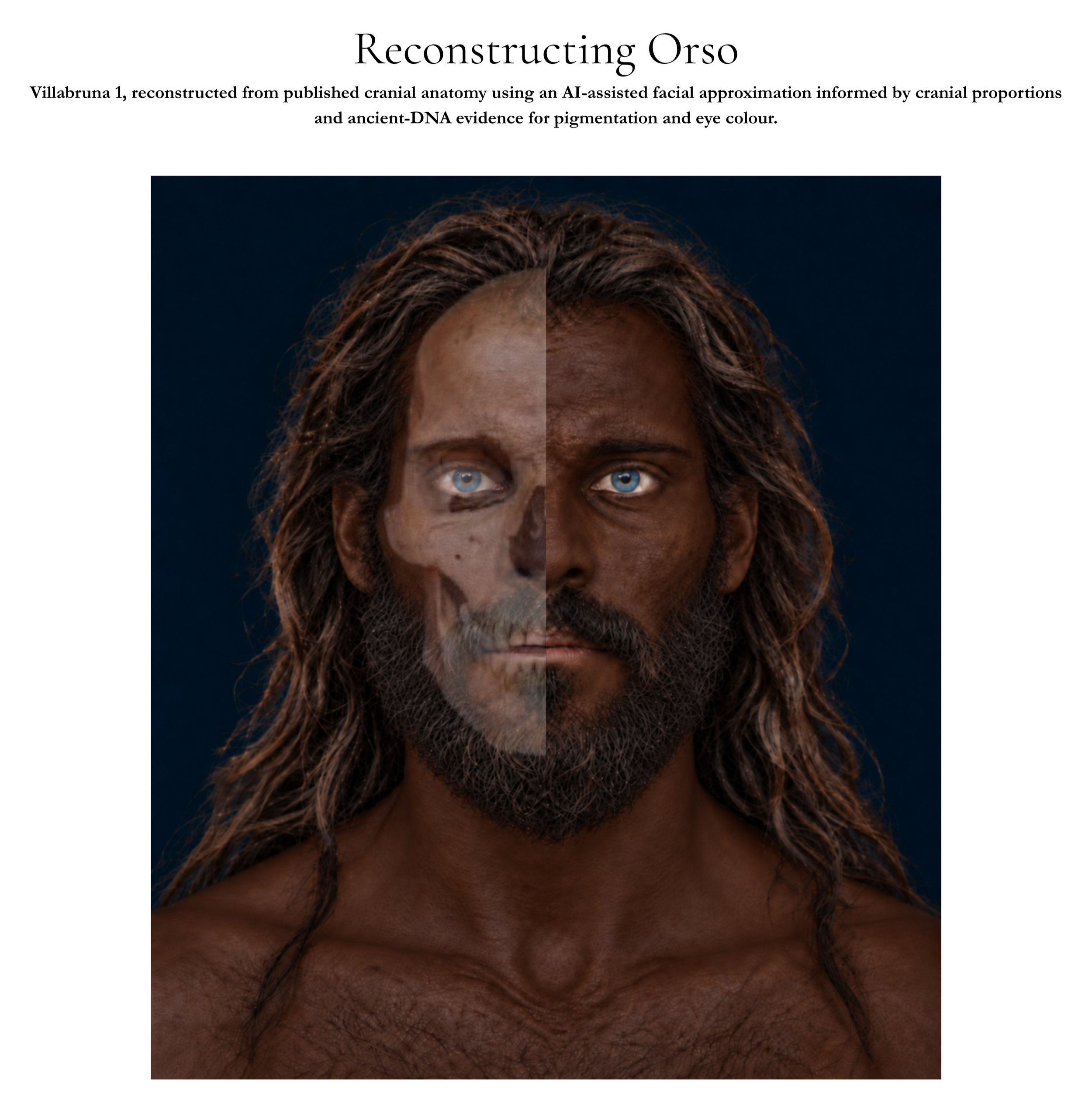
Villabruna 1: skull to face. Left: cranium of Villabruna 1, the individual behind Orso, R1b1's earliest confirmed European carrier, found at Ripari Villabruna, Italy (Vercellotti, G., et al., 2008, used under CC BY-NC 4.0). Right: facial approximation. The preserved cranium of Villabruna 1, an adult male aged approximately 25 years and dating to around 14,000 years ago, provides the anatomical basis for this evidence-informed facial approximation. Cranial form and proportions were informed by the osteological study of Vercellotti et al. (2008), while pigmentation was informed by ancient-DNA evidence reported for Villabruna in Fu et al. (2016). The reconstruction incorporates the ancestral alleles at SLC24A5 (rs1426654) and SLC45A2 (rs16891982), two major loci associated with lighter skin pigmentation in present-day Europeans, together with the derived variant at the HERC2/OCA2 locus (rs12913832) strongly associated with blue eye colour. The resulting portrait is an AI-assisted, evidence-informed approximation rather than a definitive likeness; soft tissue, hair and other features that cannot be recovered directly from the cranium or genome remain interpretive.
Orso was part of a much broader population movement already under way. Villabruna-related ancestry was present in Italy by at least 17,000 years ago, and from around 14,000 years ago spread much more widely through central and western Europe. By the time Orso was buried, people carrying this ancestry were already becoming an important part of the post-Ice Age hunter-gatherer population across much of the continent.
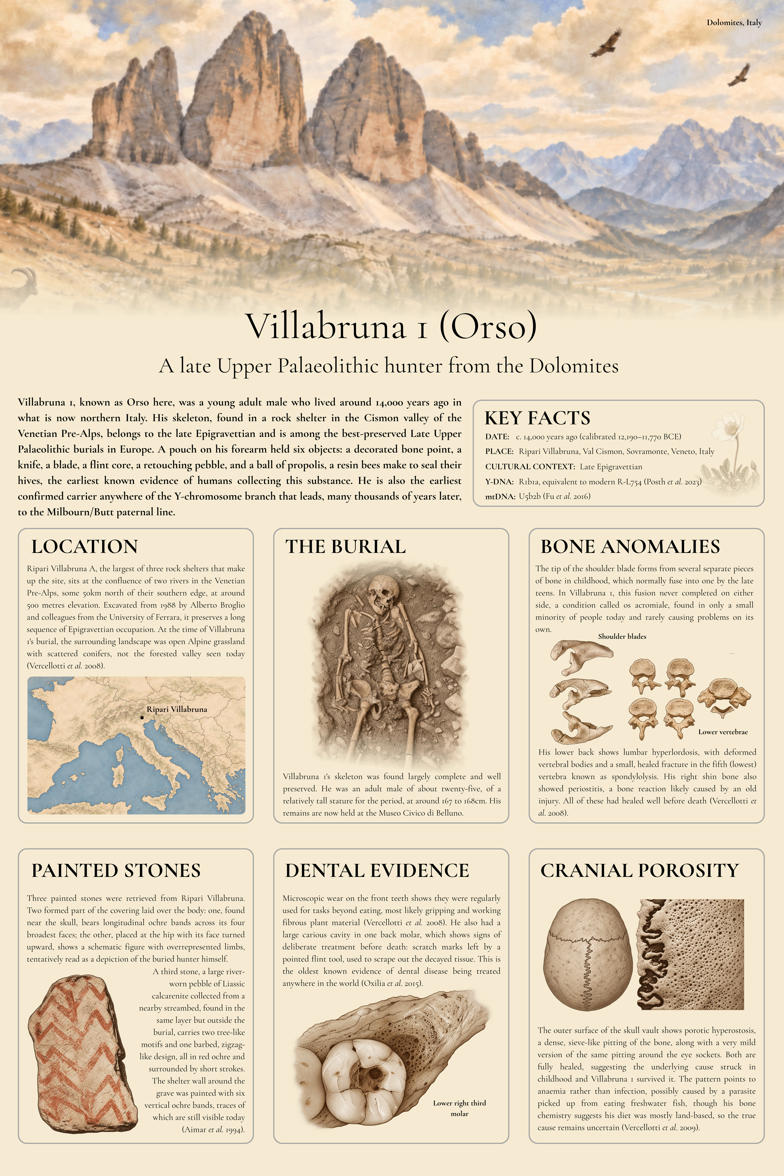
Villabruna 1: at a glance. A summary of the archaeological, skeletal and genetic evidence for Villabruna 1, the individual behind Orso, R1b1a's earliest confirmed European carrier, found at Ripari Villabruna, Italy. The location map is built from real elevation data (SRTM15+, via OpenTopography) and Natural Earth boundary data. The burial, dental and skeletal illustrations are evidence-informed reconstructions based on published photographs (Vercellotti et al. 2008; Oxilia et al. 2015), not direct reproductions of those images. The painted stones panel is based on Aimar et al. (1994)'s original excavation description, cross-checked against photography from the Museo MUVAR, Sovramonte. Full citations for each finding appear within the relevant panel.
These people may also have looked rather different from many Europeans living there today. Among Villabruna-related hunter-gatherers, genetic variants associated with blue or light-coloured eyes were extremely common, while two of the major variants associated with lighter skin pigmentation were still almost entirely absent. This suggests that at least some of them combined darker skin with light eyes, one of several combinations found among Europe’s prehistoric hunter-gatherers.
Skin pigmentation continued to change over the thousands of years that followed. Lighter-pigmentation variants increased at different times in different European populations rather than spreading across the continent in a single wave. One important evolutionary pressure was the balance between protection from ultraviolet radiation and the need for enough UV exposure to make vitamin D at higher latitudes. Ancient DNA shows that one major light-skin variant began increasing in frequency from around 13,000 years ago.
Their physical build was changing too. Early Upper Palaeolithic Europeans had often been remarkably tall: average adult male stature has been estimated at around 174 cm, compared with roughly 164 cm among Mesolithic Europeans, a difference of about ten centimetres,. The greatest reduction appears to have taken place after the Last Glacial Maximum, with a smaller further decline into the Mesolithic. Ancient DNA suggests that at least part of this longer-term change had a genetic component rather than simply reflecting nutrition or living conditions.
Farther east, hunter-gatherer populations also carried ancestry connected to the Ancient North Eurasians of Siberia. As these eastern and western populations encountered one another, they mixed, adding another layer to the genetic reshaping of post-Ice-Age Europe. By the beginning of the Holocene, the continent was already very different from the one that had entered the Last Glacial Maximum.
At the far northwestern edge of this changing world lay a territory that was not yet an island. Britain was still connected to continental Europe by a broad expanse of dry land, and people were beginning to move back into landscapes from which humans had been absent for thousands of years.